Also, a very exciting yet unnerving note about the weather the other day. They are investigating the possible tornado in Huntington (which is not far from me at all). More tornadoes have been mentioned in the investigation of this recent June 4th outbreak. An outbreak that does not surprise me after recent readings. Especially that Mike Tidwell book. It was very scary experiencing something like that. Seeing the VERY LOW dark clouds rushing overhead with a green backdrop. Then noticing that the sky was indeed spinning. Running into the back room with the power flickering after the storm hit. A very disturbing couple of minutes that I hope are not repeated, but I will not be surprised if they are. Excessive heat watch for the weekend and Monday. Heat wave #1, here we come! Will we scrape the 100 degree mark?
Showing posts with label weather. Show all posts
Showing posts with label weather. Show all posts
Friday, June 6, 2008
Another Excellent Story... Again!
Time and time again, swimmers on this swim team continue to step up and perform past their level. A young five year old swimmer, known for holding onto walls and sometimes not listening, completed his first full lap of freestyle yesterday. After that, he never touched the wall except for at the end of the pool until the end of practice. A huge step that he made yesterday that he may not have known was so huge. High fives all around and yet another sign that the next generation of swimmers is READY AND WILLING to accept the torch. They are ready to go ahead when a huge class of swimmers graduates at the end of this summer. More new rookie swimmers continue to come to the team too in the middle age group which is an even better sign. A huge shout-out from the younger group that they too are competent swimmers. If this great progress continues - could this be the sign of things to come in the future?
Wednesday, June 4, 2008
TORNADO WATCH (447, 454)
AS OF 8:00 PM, the Tornado Watch has been extended until 1 AM. Stay tuned.
BREAKING NEWS (5:00 PM): There has been a storm report of a possible tornado in the Huntington neighborhood of Fairfax County and also in Falls Church City. Stay tuned.
Tornado Watch until 8:00 this evening. Follow along with some of the maps below. Each image can be clicked to make it larger. Refresh for latest update.
| Alert Map Key | |
| RED | Tornado WARNING |
| ORANGE | Severe T'str WARNING |
| YELLOW | Tornado Watch |
| LIME | Flood Warning |
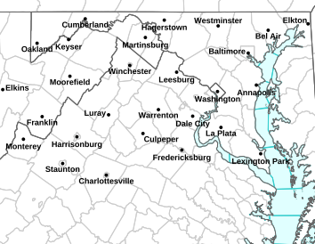
^ Radar map of DC area.
Friday, April 4, 2008
We Have Had the Onion Snow
Well this is it folks. A bit of light snow mixing in with the rain today that I believe was the onion snow. Therefore, we can officially say it is over and move on to spring! Although today didn't feel much like a spring day, tomorrow should be better... 60s possibly? Maybe close to 70? Either way I'm hoping for no rain on Saturday when I tour the ballpark.
And speaking of baseball, this summer may bring this local 3-1 baseball team a little bit closer to me. Details on that if it actually pans out. I'll keep you posted as always. We'll watch them face the Cardinals in St. Louis tomorrow night at 8:15.
Oh and another thing: the Sabres missed the playoffs, forcing me to cover up the Sabres logo that adorns the wall with a message that reads: SOME REAL HOCKEY TEAM THAT IS NOT A JOKE AND HAS A GOOD LOGO. Tomorrow I plan on changing it to just a black background, in mourning of this terrible season. Maybe next year.
Wednesday, April 2, 2008
The Hibernation Has Ended
Well, I've come out of hibernation from this blog, having written nothing since March 9th. A lot has happened in that time period, with two emotional breakdowns and all. But I swear I'm a new person, and basically it's been a few people who have brought me back up when I've been down, and I thank them profusely.
So, the Nats are 2-0!!! I know it is very early in the season, but it's exciting to see your team on top, especially considering how poorly the Sabres have done this year, with a late season collapse to keep them just out of playoff reach (although I still have some hopes that they can grab 7th or 8th). The stadium is amazing, and so beautiful. So many food options and it's just great to see a ballpark that really opens itself to DC fans. Speaking of which, my review can be found on DCSportsFan.com. You might have to look around a bit but thanks to Brian for the edits.
And now I just realized when my cursor isn't in the body text, and I press Enter, it publishes the post. So that explains the half-post for a bit.
Also, I believe that winter is now over, so that should be declared once and for all, and it's good that it is over, because I was getting tired of cold and no snow. I believe that when it's cold it has to be snowing to be enjoyable. So we are warm now, and it's a beautiful day, so I have my window open and I'm waiting for the 7:05 start for my undefeated Nats to take on the winless Phillies. Should be interesting!
And today is when I start to tag my post with labels... it's something new I'm trying out to keep some of the posts organized. So now I will start to label all the old posts and we'll see how that goes.
Saturday, March 8, 2008
Quasi Flash Freeze
We are experiencing a quasi flash freeze... temperatures that were once in the 60s have fallen dramatically. Expect temperatures to keep dropping as the next round of t'storms comes through. Very windy outside with tropical storm force winds... power outages are possible, as are trees coming down. Next round of storms is rolling through the DC metro as we speak. Winter is not over yet...
Tomorrow is going to be cold as well, but already we will see a warming trend into next week, so the cold will be short lived. But just remember that we are yet to reach spring, and this will be a reminder for a lot of people.
Tuesday, March 4, 2008
Tornado Watch (no longer) in Effect
2:00 am update: Tornado Watch has been discontinued for the DC area. Rain will end from east to west between 2 and 4 am.
The folks over at the NWS have issued a Tornado Watch on top of the Flood Warning that's already out for us. Tornado Watch goes until 3 am Wednesday morning... full coverage can be found by clicking on the Capital Weather Gang link on my blogroll.
The map below will update as alerts are issued or changed by the National Weather Service (refresh your browser for the latest map).
Image credit: National Weather Service, Sterling, VA
Legend: Yellow = Tornado Watch, Red = Tornado Warning, Purplish-Red = Severe Thunderstorm Watch, Dark Green = Flood Watch or Flash Flood Watch, Light Green = Flood or Flash Flood Warning
Thursday, February 21, 2008
Nowcast - 9:00 am Fri
9:00 am update: Looks like some freezing rain falling outside. I heard the scrape of shovels but that is done. I'm assuming it was too tough to shovel the ice, because I haven't been outside and am guessing that the ice layer is fairly thick from hearing observations around the area. Looks like we're in for a bit more ice, as the radar shows. My guess is we do get close to the quarter inch of ice, and it also appears that the cold air is holding tough, except directly in the city of Washington. Closest observing station to me is reporting in the upper 20s. We'll see how long the cold air can hold on, but my guess is it isn't going anywhere soon. Next update will either be around 10:30 or noon (depending on when I wake back up again - UMD closed til 11!).
4:00 am update: Nothing falling in CP, but the radar echoes are continuing to fill in. Looks like we will get our precip after all... just less snow than expected. Will update in 4 and a half hours... be careful on roads in case of slick spots!!!
3:00 am update: Still no steady snow in College Park, but we have had off and on light snow/sleet for a bit. Radar seems to really be filling in a lot more, and apparently pressure values are falling off the Carolina coast... so if that means a coastal is forming, a bit more moisture could be thrown our way, giving us a shot at the significant snow and ice that we snowlovers so truly desire. Still watching that southwestern edge for the filling in of the dry slot. Next update will probably be at 8 am tomorrow.
1:15 am Update: The snow has started, very light, here in College Park, but it's already tapering off. Radar shows the first batch moving out, but it almost appears as though it's filling back in over in the Charlottesville area. Let's watch to see if this fills the entire DC area with snow. Next update (I hope) will be tomorrow morning, 8ish. If I'm still up, I'll update around 2:30 am.
Snow begins between now and 1 am across the area, and light snow will continue overnight. Expect a changeover to sleet and/or freezing rain sometime tomorrow, and I'll nail down that changeover in a later post. So, it may not be snowing where you are, but just keep the faith. Hopefully the snow hole can fully fill in and that dry slot can fill in with some snow too. Keep it tuned.
Next Storm... Tonight!
Next storm coming in. Brief comments. I think anywhere from a dusting to three inches of snow before a changeover to ice. Yes, the snow range is broad but there are concerns over the dry slot forming and whether or not that closes up. If not, only a dusting (if that) can be expected, but if it does, it could be closer to three inches. Then significant ice tomorrow, unless something changes. Still a lot of unknowns, but could be around quarter to half inch of ice. Winter Storm Warning in effect... batten down the hatches, folks.
Tuesday, February 12, 2008
11:45 pm Update
Conditions drastically improving out there... this doesn't count for the entire area though. It's going to be interesting tomorrow morning... the temperatures are going to be right around freezing through the night, but should start to rise shortly. I'll keep an eye on it.
Sirens are Wailing... 9:30 pm update
Sirens are wailing out there in College Park, and that means icy conditions. It's going to stay cold (27 right now) overnight... probably warming above freezing sometime tomorrow. Very tricky forecast, but the Ice Storm Warning remains until 7 am... numerous cancellations and/or delays tomorrow morning. Travel is going to be very difficult, and I will say that this storm surprised many people... it was supposed to be above freezing by now.
Stay tuned.
Monday, February 11, 2008
Another Case of Shoulda, Woulda, Coulda
Well it was a mistake not waiting in the mile-long line that was for the Obama speech here on campus today. Even though it was a mile long (and yes, I measured it, and it's all thanks to the folks at USA Track and Field that I was able to do it inside where it was warm -- 0.98 miles, which is close enough to call it a mile), I should have waited and I still could have gotten in. Oh well, we learn from mistakes every day. That's one of them. I was still able to catch the speech on News Channel 8, though, and that was good.
Huckabee is still my top choice, though, and it's really because of his stance on abortion. Obama is right behind him, and then there is a drop off before you get into the territory of McCain, Clinton, and... Ron Paul and Mike Gravel. The thing is, my political views are so odd and across the board that the extreme folks really cater to my whims... which is why many people are questioning my huge support for Huckabee. Btw, I got to meet Huckabee after his speech on Saturday... got a photo, autograph, and handshake, and he also answered my question about Roe v. Wade and how it would most certainly be gone if he were to take office in 2009!
It really does need to snow around here, as it's been a while. People are calling this winter over, but I'm not ready to wave the white flag yet. It seems as though there are some signs of La Nina, which has been roaring away for the past few months, finally giving out. Could this mean more snow? That's a good question, and it's something we really need to watch for. Tomorrow could be interesting with a spot of wintry weather, but I honestly do not see it as a major threat. However, things can always change, and as always I will provide updates if needed.
Goodnight, Maryland, and vote smart tomorrow!
Also, an explanation on my politics...you'll remember I've taken this test before:
| You are a Social Moderate (43% permissive) and an... Economic Liberal (35% permissive) You are best described as a:
Link: The Politics Test on Ok Cupid Also: The OkCupid Dating Persona Test |

Friday, January 18, 2008
Okay, so, next storm?
Yes, another one could be coming this way Saturday. It's a close call right now. But whether we get 0.1", 1.0", or 10" is another story... I'll keep an eye out for this one.
Thursday, January 17, 2008
Who Called It?
Okay so there was no set entry on the storm, but I'd like to say I got this one right. Last night I saw the storm coming in quick, and I said that we would get some more snow than the local mets predicted. I didn't like the maps they were issuing and I instead chose a forecast of more of a gradual increase from east to west. Generally, from what I have seen and heard, I was correct. I called for 1-2 inches immediate metro DC and south and east... inch or less and rain further out... and more snow off to the west. I nailed this one, and I'm hoping I nail the next one, coming up on Saturday.
Right now I'd place the possibility of accumulating snow at 20%. But we'll have to wait and see... there's tonight's teaser.
Tuesday, January 15, 2008
Snow is coming in sideways!
In vantage here, snow is coming in sideways! This is probably the heaviest snow I have seen in a few years, but unfortunately it won't amount to much. Half an inch at most with no accumulations on the sidewalks or roads, really. Unless it starts getting colder, as I've got 36 here, which actually just dropped to 28 so I guess some accumulations are possible before it ends here within a half an hour.
But I'm excited for the next couple weeks. Cold air coming in, conditions going just right!!! I'll probably be quiet so I don't jinx anything... but I think the next few weeks could be much more interesting... let's leave it at that.
Sunday, December 16, 2007
Politics and Yesterday's Storm
Well I was going to go more conservative than Capital Weather and say we would not get much freezing precipitation at all, so I lose on that one. But if I had said that it would have been a nice prediction. The storm impact of two flakes was off and so was the road impact... the roads were fine in the metro area, and I'm not sure about north and west of here. Give me a C+.
Also, I took a politics test. Here are the results:
| You are a Social Moderate (55% permissive) and an... Economic Liberal (30% permissive) You are best described as a:
Link: The Politics Test on Ok Cupid Also: The OkCupid Dating Persona Test |
Saturday, December 15, 2007
The Final Guess (3:00 PM)
Okay, well here it goes... the guess that I will be taking... and I think that I'm going to take a page out of Capital Weather's book. Here it is, the timeline:
5:00 PM Sa - 9:00 PM Sa - Snow, sleet, and freezing rain develop... areas south and east maybe a changeover?
9:00 PM Sa - 12:00 AM Su - DC Metro area and south experiences change to rain.
12:00 AM Su - 4:00 AM Su - Heavy precipitation. Warm air cuts north to continue changeover
4:00 AM Su - 9:00 AM Su - Rain.
9:00 AM Su - 12:00 PM Su - Any remaining rain exits to the north and east.
Taking another page out of their book:
Storm Impact: I'm giving this two flakes, just because of the possibility that significant icing could occur in our north and west suburbs.
Travel Impact: Forget the airplanes... I'm going to go with road conditions. Two and a half cars, because of the way these morons around here drive.
School Chances (Monday): One apple. You're going to school... face it.
Next Storm Chance: Dec. 20th is the next day showing up on the GFS for a chance of any type of precipitation. Best guess now would be rain.
Friday, December 14, 2007
Not Getting Excited for The Weekend Storm
One word: rain. The NWS is hyping up the system coming in this weekend and it's not going to be as cold as they say. I can see it now, hoping for an inch of snow and ice and getting the short end of the stick yet again. DC, enjoy that clipper we had a week or two ago, because it may well be the last big one we see this winter. I know it's early but when this pattern keeps up, you can kind of see where this is going. I've had it with DC's winters.
The Struggles Continue. We are Burning Late Night Oil As We Speak
STUDYING IS GOING NOWHERE... TRYING A DIFFERENT TACTIC THAT I LEARNED ABOUT EARLIER IN MY ENGLISH PAPER... IT IS 4:45 AM AND I AM BEYOND TIRED... I'VE ALL BUT GIVEN UP... WINTER STORM WATCH SATURDAY TO SUNDAY...
Figure I'd switch directions. An idea was proposed by Gallup... basically you should work on your strengths rather than working on your weaknesses so you can play to your strengths. I am a strong writer...
History Grade Waning with Snow Chances for the Weekend
And just after midnight I start studying for history... the exam is at 8 with a breakfast at 7 am. I have four Sobes remaining in my fridge. I will spread those out over the night so I can stay awake and study to the best of my ability. We'll see... maybe I will do a clutch move for the fourth time in the past two days. Yesterday (Thurs) I pulled clutch moves thrice... on two exams and a paper. Both exams mattered a lot, and I destroyed them... in a good way. The paper was due before Friday and I finished it at 11:45 pm. These clutch performances hopefully continue tomorrow with my History exam. It's going to be difficult but I'll try my best.
As for snow chances this weekend, do not count on them. Best shot is for a miracle to happen, but I think we'll go mix to rain to mix or snow. Not that much to worry about, but as usual, I'll keep an eye out on it all. After all, the dusting to one inch forecast for the clipper turned out to be five inches here in College Park. Who knows?
Good night, Maryland. Maybe another update as I burn the midnight oil.
Wednesday, December 12, 2007
December 15th-16th
There is the possibility of you-know-what... here's the potential as I see it in the early morning hours of Tuesday... as I should be studying, this is what I'm doing...

The area north of the northern yellow line is most likely going to see all snow. This is a confidence line. That is the area where I believe will not have to worry about a changeover. The area south of the southern yellow line (the other confidence line) will most likely be all rain. In between is where it gets confusing and is the area that needs time to analyze what will fall there. It's going to be a tough forecast there. Could be snow, could be rain. The area I have outlined in light blue is MY forecast area for getting all snow (or mostly snow). The area in pink will get snow, ice, and possibly rain in my forecast. And the area in green is my forecast for rain. Now as the computer models have been shaky, I've outlined some potential areas too. The dashed blue section is where there is a possibility for heavy snow. The dashed red area is where there is a possibility for sleet and freezing rain to make for tough travel.
Subscribe to:
Posts (Atom)